-
 Map of the West China Union University Campus
 This map of WCUU was evidentially created in the 1930s, judging by the buildings that are included. The buildings have been numbered in the order in which they were built, which gives a good idea of the growth pattern of the campus.
Concerning the location where pandas lived on campus, David Crockett Graham is thought to have lived in the Baptist houses at 64,65,66 or 67. Pandora, Pandee and Pandah lived with the Grahams there. The Dickinsons, Agnews and other Canadians lived on "Canadian Row," at numbers 36-44 and 92-97. Pandora, Pan, Lien Ho, Happy, and other of Floyd Tangier Smith's pandas lived there.
-
 Map Detail of Region between Wolongguan and Maoshuizi
 This map continues Beatty's and Vinden's trek on their homeward journey from Wolongguan to Maoshuizi, where they saw the baby Pandora panda. They would have left the Shaotang River (P’i T’iao River) at Huachaodi, crossed over the Niutoushangou (Niu T’eo or Shan Cow’s Head Pass), picked up the Zhonghe River at Maluiping, which they followed to Maoshuizi, where they found Pandora for sale. From Sanjiangxiang (San Chiang Ko), where they stayed the night, they were able to get back to Dujiangyan the next day.
-
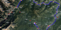 Annotated Map of the Route between Caoping and Wolongguan
 This map's annotations show the key locations mentioned by Beatty in the third and fourth days of his account of his and Gilbert Vinden's trip into tribes country in 1938. Starting at Caoping on the third day, the pair left the riverbed to cross over mountains. They went through Maoshuizi (Mao Shin Tze - the red dot in the middle of the mountains), across the "Cow's Head Pass," and on to Wolongguan by the fourth day.
-
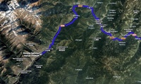
 Annotated Map of the Route between Xuankoucun and Caoping
 This map's annotations show the key locations mentioned by Beatty in the first two days of his account of his and Gilbert Vinden's trip into tribes country in 1938. Starting from Dujiangyan, the pair made it on foot to Caoping in two days. This part of the route follows the Shouxi River all the way. Maoshuizi (Mao Shin Tze), where the pair encountered baby Pandora on their way back is also indicated.
-
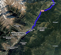
 Map Showing Relation of Panda Captures to Panda Reserve
 At least two baby pandas were captured near Wolongguan - Pandora in 1938 and Pandee in 1941. This is where there is a large nature reserve today.
-
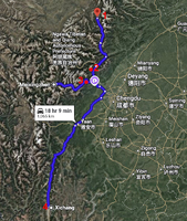
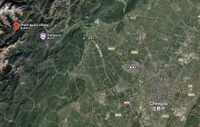 Map of Region between Chengdu and Wolongguan
 Google map showing overview of distances between Chengdu and Dujiangyan, and Dujiangyan to Wolongguan, near where at least two baby pandas were captured - Pandora in 1938 and Pandee in 1941.
-
 Annotated Segment of Helde's "Part of Western Szechwan"
 This is a small segment of a much larger map produced by George Helde, a YMCA missionary, on trips he took to the western hill country in 1921 and 1922. Helde had just lost his wife in childbirth at Mt. Emei when he set out in 1922. The annotations show locations on the route that Edward Beatty and Gilbert Vinden took on their journey to Mowkung in 1938 when they encountered Pandora the baby panda in Maoshuizi village on their return trip. Beatty and Vinden took the same route that Helde documented in 1920.
-
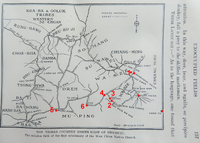 Annotated Map of Tribal Regions in Sichuan's Southwest, 1920
 The map shows tribal territories in Western Sichuan as missionaries understood them before 1920. The portions labelled "Wasze" are where Wassu hunters were successful in capturing live baby pandas for foreign buyers, including David Crockett Graham, Frank Dickinson, Walter Small, Daniel Dye and others.
-
 Annotated Google Map of Panda Territory
 This map shows panda territory extending from Songpan in the north to Xichang in the south, with locations indicated were famous pandas Sulin and Pandora were captured.
-
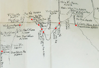
 Annotated Map of West China, 1920
 This map of the mission stations in West China in 1920 has been annotated to illustrate key locations in panda hunting territories, which stretch from Songpan in the North to Xichang in the south. Key cities are also included for orientation.
-
 1938 Trip to Wolong and Pandora the Panda
 This event describes and illustrates the journey of Edward Beatty and Gilbert Vinden on the route to “Mao Shin Tze” [Maoshuizi] where Pandora the baby panda was captured in 1938. This town is near Wolongguan where another baby panda, Pandee, was captured in 1941. There is a panda reserve at Wolongguan today.
-
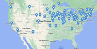 Interactive Map of West China Missionaries' Birth Places, USA
 The map presented here is based on birth place data for missionaries who served in West China, 1885-1952, researched and compiled by members of the Imaginaries and Modernities research team. It does not encompass all such missionaries, but enough of them to present clear trends in their places of origin. Here we present a still image of the USA map, which shows a wider geographic distribution than does the data from Canada, while still following the pattern of concentration in the northeast and midwest.
Follow the "Source" link to an interactive version of the map where you can drill down to individuals' birth places. Click on a "pin" to see the name of the missionary and their hometown.
-
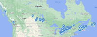 Interactive Map of West China Missionaries' Birth Places, Canada
 The map presented here is based on birth place data for missionaries who served in West China, 1885-1952, researched and compiled by members of the Imaginaries and Modernities research team. It does not encompass all such missionaries, but enough of them to present clear trends in their places of origin. Here we present two still images of the data from Canada - the whole country and just Ontario. The first shows a strong concentration of birth places in central Canada while only a scattering of individuals in the east and west. The latter shows that a disproportionately large number of West China missionaries were born in Ontario, even when one includes those born in the USA or UK.
Follow the "Source" link to an interactive version of the map where you can drill down to individuals' birth places. Click on a "pin" to see the name of the missionary and their hometown.
-
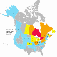 Map of North American Birth Places of West China Missionaries
 This map is based on genealogical data Cory Willmott and Amy Kaler compiled for 500 missionaries who served in West China. The data for the map represents a subset of this data of the 382 missionaries who were born in North America. It demonstrates how in both Canada and the US, the majority of missionaries were born in the Northeast or the Midwest, while only few are born in the South or West. The anomoly is that almost half (48%) of the West China missionaries were born in Ontario. This is out of proportion to their numbers in West China where Canadians represent only about a third of the missionaries, the others being born in the various countries of the United Kingdom, China and other foreign countries.
A likely explanation for the huge number of West China missionaries born in Ontario is that the Canadian Methodist Mission had only the West China mission, whereas other mission societies had missions in other parts of China, as well as in other parts of the world, which limited the number of missionaries they could send to West China. Another reason is that Ontario Protestant communities shared common origins and were extremely tight knit, providing the social environment in which ideas could easily be materialized into actions. Finally, funnel institutions such as Toronto's Victoria College and Ontario chapters of the Epsworth League and the Student Christian Movement efficiently recruited for the West China mission.
-
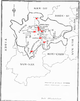
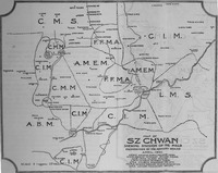 Map of West China Mission Fields, 1902
 This map shows the regions assigned to each of the missions in Sichuan by the West China Advisory Board in 1902.
-
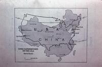 Map of China Superimposed on the U.S.A.
 Figure that demonstrates an outline of China placed over the United States. Can be used to compare the sizes of the two countries. Olin Stockwell either used or planned to use this image in slide lectures that he gave in North America to promote their mission work.
-
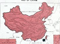 Topographic Map of China
 Topographic map of China that shows the Szechwan Basin and mountain ranges in the west of Szechwan. Olin Stockwell either used or planned to use this image in slide lectures that he gave in North America to promote their mission work.