-
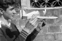 Omar Walmsley Holding Model Hawker Fury Biplane
 Omar Walmsley is holding a model Hawker Fury biplane next to a brick wall with ironwork at the top.
-
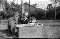 Teenage Boys with Model Airplanes
 From left to right: Don Willmott, Omar Walmsley and Bill Phelps behind a table with model airplanes they have built.
-
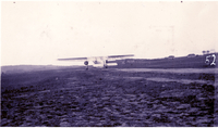 Fokker F.VIIb/3m Plane Taking Off
 A Fokker F.VIIb/3m trimotor monoplane is seen from behind as it takes off from the the Chengdu Fenghuangshan Airfield (成都凤凰山机场).
-
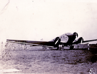 Lufthansa Junker Ju 52 on Chengdu Airfield
 A Lufthansa Junker Ju 52 on the Chengdu Fenghuangshan Airfield (成都凤凰山机场), which had been recently built 15 miles northwest of the WCUU campus.
-
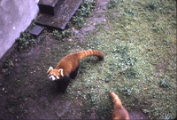 Red Pandas at Xiqu Park, 1975
 A red panda and the back half of another red panda in a zoo enclosure.
-
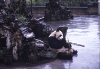 A Panda Sitting on Ice at Xiqu Park, 1975
 An adult panda holds a stalk of bamboo while sitting on what appears to be ice in a zoo enclosure.
-
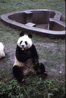 A Panda Chewing Bamboo at Xiqu Park, 1975
 An adult panda sits on the grass with a bunch of bamboo in front of it. An empty heart-shaped pool is in the background behind it.
-
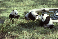 Three Pandas at Xiqu Park, 1975
 Three adult pandas sit on a lawn with a large batch of bamboo. There is a concrete pool of water next to them.
-
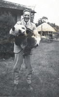 Dryden Phelps Holding a Panda
 Dryden Phelps is standing in the Graham's yard holding Pandah, who is on a leash. Dryden has clips around his trousers, which suggests he was riding a bicycle. A thatched-roof pavilion can be seen in the background.
-
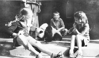 Two Girls and a Boy with a Panda
 Bill Willmott and two unidentified girls sit on a porch with Pandah. A servant is on the porch with them. The older girl holds Pandah's leash.
-
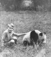 Bill Willmott Petting a Panda
 Bill Willmott sits on the lawn with his hand on the back of Pandah, one of the pandas captured in 1941. The panda is on a leash. A brick wall is in the background.
-
 1975 Willmott Trip to China
 This Event compiles color slides taken by Earl Willmott on his 1975 trip to China with his wife Katharine hosted by the People's Association for Friendship with Foreign Countries.
-
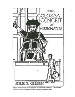 Woodblock Print - The Colossal Conceit of Missionaries
 The image shows a massive figure drawn in the style of Chinese temple statues. He is wielding a sword and presiding over what appears to be a court. In a much smaller scale, a man with a doctor's bag holds the page of a book open on the desk of the court. The symbolic meaning is up for interpretation.
-
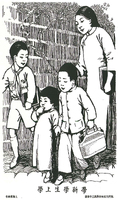 Woodblock Print - Off to School
 A family consisting of a mother, two sons and a daughter walk alongside a stone wall. The oldest boy is wearing a scout uniform, an indication of his membership in the Guomindang youth club, while his younger brother wears the zhongshan suit first popularized by Sun Yatsen. The mother and daughter wear scholars' gowns, showing their status as "New Women," an image promoted by the GMD.
-
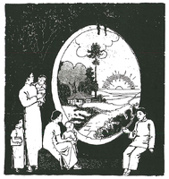 Woodblock Print - New Dawn though the Moon Gate
 This print shows an extended family consisting of grandmother, son, daughter-in-law and three children sitting in front of a circular "moon gate." The grandmother and the baby are looking away from the gate, while the rest of the family are looking through it. The scene that appears before them is a countryside with a small cottage in the mid-ground and a rising sun in the distance. The grandmother wears the women's traditional jacket with trousers, while the son, daughter-in-law and child wear scholars' gowns.
-
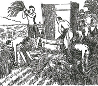 Woodblock Print - Threshing Rice
 Four men working in a rice field - two of them are tying the rice into sheaves, while the other two are threshing the sheaves in a conical wooden device for that purpose. They wear only cotton trousers.
-
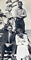 Willmott Family at Go Home Bay, 1914
 Walter, Margaret, Evie and Earl Willmott pose for an informal portrait at their summer cottage in the Madawaska Club at Go Home Bay.
-
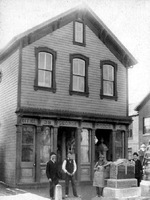 George Dodds in Front of his Monument Business Storefront
 George Dodds (far left) stands in front of the storefront for his monument business in Xenia, Ohio, with several relatives and employees. Carved gravestones are on display in the yard or sidewalk. The three story building also housed his family, including his daughter Carrie Dodds Geyer after her husband's death, along with their three children, Mary Katharine among them.
-
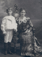 Margaret Thom Willmott with her son Leslie Earl Willmott, c.1902
 Margaret Thom Willmott and Leslie Earl Willmott pose for a formal portrait in a studio. Margaret is seated on a wooden chair with elaborate carving. She wears a fashionable dress with tiers of black lace over a light-colored undergown with a chocker-style pearl necklace with jeweled drop. Her expression is mildly smiling. Earl wears a breached white linen sailor suit with tall black socks and leather boots. His head is slightly cocked away from his mother, perhaps a foreshadow of the unconventional personality of his grown up self.
-
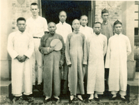 Earl Willmott with Staff of Jenshow Boys School
 Earl Willmott poses at back left with the principal and teachers of the boys' middle school he was in charge of in Jenshow, 1922-1933. All the men (except Earl) wear scholar's gowns with cloth shoes. Two of the men wear scholar's hats, and one holds a fan.
-
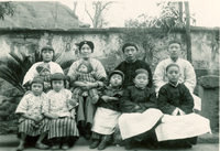 Portrait of Chinese Pastor's Family
 Multigeneration family consisting of Liang and his wife, son and his wife, three boys, two girls and two babies. Note that the girls have "natural feet," having given up foot-binding as Christians and modern Chinese.
-
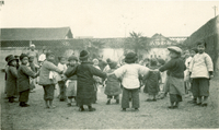 Chinese Children Play a Circle Game
 A large group of children hold hands together in an inner and outer circle, probably playing a game or singing a song. Many of them are looking at the camera with expressions ranging from suspicion to happiness. They wear padded clothing and many of the boys wear hats. A Chinese woman - probably their kindergarten teacher - stands in the back left. They're on the lawn within the mission compound.
-
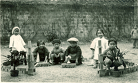 Six Chinese Children Playing with Blocks
 Six well-dressed Chinese children pose in an enclosure made of wooden blocks. There is a brick wall behind them and another child off to the right.
-
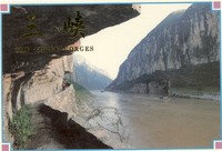 Postcard of the Qutangxia Gorge
 The panoramic scene is shot from a trackers' path cut out of the rock face. Two boats can be seen on the river, which courses between vertical rock cliffs on both sides. A few people can be seen on the trackers' path, obviously tourists, not trackers. "The Three Gorges" is written in gold letters in both English and Chinese on the front.
-
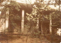 Willmott House in Jenshow, c.1970s
 A large two-story house with double wrap-around verandahs. The yard appears to be unkept with scrappy trees growing up randomly and neither flowers nor grass lawn.

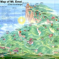 1930s Willmott Family Mt. Omei Journeys